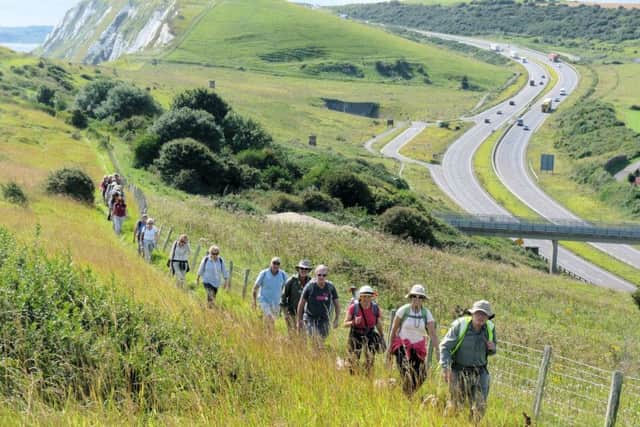
Discover Battle with the Ramblers


The best way to discover the beautiful countryside in our county is to get out on a walk.
If you are unsure of where to start, or finish, the Ramblers share one of their favourite walks in East Sussex.
Battle in brief
1 hour 40 minutes 4.3km / 2.7mi leisurely
Route developer: Jonathan Williams
Route checker: Bev Marks
Start location: Battle rail station
Getting there:
Advertisement
Hide AdAdvertisement
Hide AdBattle Rail Station is on the London-Hastings line, about 20 minutes from Hastings and about 1hr 20m from London Charing Cross. It is also serviced by a number of local bus routes, which stop opposite the road to Battle Station and carpark. Ticketed parking is available at the station.
Description:
[1] Turn right out of Battle station and find the path at the end of the car park (next to the railway tracks). Continue along this path until you meet the road.
[2] Cross the road, turn left up the hill. After about 200m after the white house (called White House) you will pass the road to the Battle Cemetery on the right which is worth a short detour in spring and summer as it is a wildflower reserve.
As you approach the top of the hill, a wonderful view opens up on your right over a field managed by the National Trust. Taking in the view, you can see the route you will follow taking a nearly straight line across a small hill to some white cottages, then up a larger hill, where the path disappears into the trees on the ridge. Look a little to the left and you might just be able to make out the blades of the windmill.
Marley Lane can get busy, so keep an eye out for traffic
Advertisement
Hide AdAdvertisement
Hide Ad[3] Before you reach the roundabout, turn right through the wooden kissing gate into the field and continue more or less straight down the hill as indicated by a concrete ‘footpath direction marker stone’. Cross the footbridge and continue ahead and down to a second footbridge. From here, take the track veering slightly left across the field to another bridge and follow the finger post direction to a hidden metal kissing gate onto the farm lane. (Ignoring informal tracks going right.)
The 1066 Country Walk, a sign for which you will see at the first kissing gate, runs 50km/30mi from Pevensey to Rye.
Pevensey was where William (Duke of Normandy) landed his army before going on to Battle to defeat King Harold in the Battle of Hastings. The 1066 Country Walk passes Battle Abbey as well as the castles at Pevensey and Herstmonceux. This section can get muddy and slippery, so bring your boots and/or poles after heavy rain.
[4] Turn right along the farm lane for about 30m, then turn left at the waymarked footpath. The right of way goes diagonally across the field towards the white cottages (where you might be able to buy some eggs), then across the next field to the hedge. Cross the small ditch and go through the hedge, then turn left uphill along the edge of an immature arboretum, aiming just left of the houses. Join the driveway and continue straight past the houses down to a road.
Advertisement
Hide AdAdvertisement
Hide AdRemember to turn around and admire the view as you climb Caldbec Hill. On the right you will see Battle spreading along the ridge (the route King Harold took to the Battle of Hastings) and you may be able to make out Battle Abbey and St Mary’s church, which you will pass later in the walk. The large plantation wood stretching ahead is Battle Great Wood.
[5] Cross the road and a stretch of grass to join the sealed path, then go left for about 200m. Turn right up a driveway/track (signposted as a public footpath with one of East Sussex’s easytomiss concrete ‘footpath direction marker stones’ if you get to the large curving brick wall, you’ve gone too far). Follow the driveway and admire the windmill (B) and continue directly past the adjacent buildings on right through the hedge into the Kingsmead Open Space (C). When you’re ready, retrace your steps to the road, cross to the other side and continue right downhill for about 500m until you reach Battle High Street.
Kings Head Windmill (or Caldbec Hill Mill) is a Grade II listed smock mill, built in 1805 and in use until WWI. It is now a private residence.
Kingsmead Open Space is a fantastic spot to stop for a rest and soak in the view towards Netherfield Hill and its distant church tower. This wildflower meadow spectacular in spring and early summer has a part growing from the London 2012 Olympic Legacy turf donated to the town. This is Caldbec Hill, where King Harold and his troops rested on the night before the Battle of Hastings (although some locals argue that this might be the site of the battle itself). You might like to think as you continue the walk that you are retracing their exact steps as they marched to battle.
Advertisement
Hide AdAdvertisement
Hide AdTake note of the eclectic buildings along this road, including cottages dating back to the 15th century; Lewins Croft, a very old, wonky timberframed Grade II* listed building; and the 19th century Zion Chapel. Almost every building you pass from here to the roundabout (I) is heritage listed.
Be careful crossing the roads, especially in places where there are no marked crossings.
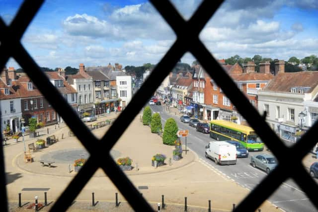
[6] Turn right at Battle High Street, cross at the pedestrian crossing, then go left back down through the centre of town to the Abbey Green and the castlelike gatehouse of Battle Abbey.
Once you have finished looking around, cross the High Street using the pedestrian crossing near Costa/the Post Office and continue right for about 350m, with the high Abbey wall on your right, past St Mary’s church to the roundabout.
Advertisement
Hide AdAdvertisement
Hide AdThis unassuming roundabout was recently declared by TV’s “Time Team” to be the most likely position of the Battle of Hastings, as it is where the ridge ends and dips down along what is now Lower Lake. Whatever the exact location, the fact is that the Normans won which is clearly why the nearby sign pointing to the town centre is written in French.
From here, retrace your original steps left down Marley Lane to the rail crossing, then right along the path back to Battle Station.
Just a few points of interest on Battle High Street include: the gardens around the Museum and the Almonry (ahead of you as you cross the first pedestrian crossing); the Bull Inn, built with stones from the Battle Abbey kitchen; the triangular so called ‘Abbey Green’, with the traditional site of the annual Battle Bonfire marked out in the cobbles; and Pilgrim’s Rest on the Green, an extraordinary 15th century Grade II* listed timberframed Wealden type building.
Battle Abbey was built on what is generally considered to be site of the Battle of Hastings. The Pope ordered the Normans to do penance for killing so many people during their conquest, so William the Conqueror built this abbey with the church to be located on the exact spot that King Harold fell. The abbey was mostly destroyed during the Dissolution of the Monasteries under King Henry VIII, but there is still plenty to see (including the ‘official’ battlefield) if you have the time. It is operated by English Heritage, so check their website for opening hours and entry prices:
Advertisement
Hide AdAdvertisement
Hide Adwww.englishheritage.org.uk/daysout/properties/1066battleofhastingsabbeyandbattlefield/
St Mary the Virgin church. St Mary’s was founded by Abbot Ralph in around 1115. Although now faded, the church once exhibited one of the most impressive painted interiors of the middle ages in Sussex. There are also three brasses of note dating from 1426. On some evenings (currently Tuesdays), the campanology society practices.
Discover the joys of walking…
The Ramblers helps everyone, everywhere, enjoy walking and protects the places we all love to walk. Join up to help build a Britain designed for walking.
For as little as £3.25 a month you can benefit from over 45,000 group walks across Britain, access to over 2,700 Ramblers Routes, a monthly e-newsletter, four issues of Walk magazine a year plus online access, 15 per cent off at Cotswold Outdoor and other partner discounts, the use of its map library and free entry to our membership events across the UK offering specialist workshops.
Advertisement
Hide AdAdvertisement
Hide AdJoin at www.ramblers.org.uk/join or call 020 7339 8595 (Monday to Friday, 9am until 5pm).
Battle Abbey Picture: James Dennett
View from Battle Abbey towards Battle High Street.
Ramblers Pictures: Rob Riddle